Pribram.eu Život v Příbrami Životní prostředí a odpady Voda a ovzduší Flood warnings and river levels
Živ. prost. a. Voda a ovzduší Povo. výs. a.
Flood warnings and river levels
The Flood Forecasting Service informs the flood authorities (local authorities) and, where appropriate, other parties involved in flood protection (members of the public), of the possibility of a flood occurring and of any further dangerous developments, as well as of the hydrometeorological factors decisive for the onset and development of a flood, in particular precipitation, water levels and discharge rates at selected (forecast) gauging stations. This service is provided by the CHMI in cooperation with river basin authorities.
For further information, see: http://hydro.chmi.cz/hpps/
Automatic monitoring profiles. The town of Příbram, in cooperation with certain local authorities, operates 12 automatic monitoring profiles on watercourses within the Příbram Municipal Authority area. These watercourses are: the Litavka, Skalice, Kocába, Příbramský p., Obecnický p., Hrádecký p., Lazský p., Modřejka, Svojšický p. and Věšínský p.
Water levels and/or flow rates are displayed at regular intervals at the following addresses:
https://stanice.fiedler-magr.cz/index.php?odesli=P%F8ihl%E1sit
(Login details: Username: pribram, Password: pribram)
http://www.pvl.cz/portal/sap/SmartPhone
Flood activity levels (FAL) express the degree of flood risk. They are linked to reference limits, which are usually water levels or discharge rates at reporting sections on watercourses, or to threshold or critical values of other phenomena (daily rainfall totals, water levels in reservoirs, the formation of ice jams and blockages, ice drift, threshold or critical values of monitored phenomena in terms of the safety of hydraulic structures, etc.).
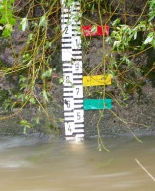
green – first level of flood activity (state of alert)
is declared when there is a risk of a natural flood and is lifted once the causes of such a risk have ceased; it requires increased attention to be paid to the watercourse or other source of flood risk, and the reporting and patrol services commence operations; at waterworks, this status is declared when the threshold values for monitored phenomena and conditions relating to the safety of the structure are reached, or when exceptional circumstances are identified that could lead to a specific flood,
Yellow – second level of flood activity (state of alert)
This is declared when the risk of a natural flood escalates into an actual flood; it is also declared when the threshold values for monitored phenomena and conditions at a water structure are exceeded from the perspective of its safety; flood authorities and other flood protection agencies are mobilised, resources for safety works are placed on standby, and measures are implemented to mitigate the course of the flood in accordance with the flood plan,
Red – third level of flood activity (state of emergency)
is declared when there is a risk of widespread damage or a threat to life and property in the floodplain; it is also declared when critical values of monitored phenomena and conditions at a water structure are reached from the point of view of its safety, simultaneously with the initiation of emergency measures; protective works and, where necessary, rescue operations or evacuations are carried out.
Prepared by: Ing. Petr Walenka
Updated: 24. 12. 2009 v 15:05:05

